
Now we'll continue east from our third of three posts through time in Harrowsmith. Canadian Northern Railway (CNoR) built a Smiths Falls to Sydenham connection. The initial Harrowsmith to Sydenham line was planned to be three miles, but due to a grade between the two communities, a greater distance was more advantageous, resulting in the building of an additional 1.3 miles. The CN line enters the 1962 aerial photo (top) at mid-left, passing through Harrowsmith, then continuing east after the CP splits off to the south and Kingston. The CN hugs the top of the cliff overlooking 'the flats' to Sydenham, as the road descends to the level of the swampy land that extends south toward Murvale. The sharp curve on the CN line, engineered to ease the grade, is visible at top right.
Colebrook Road enters the photo from mid-left below the CN. Rutledge Road continues east from Harrowsmith in a west-east direction into Sydenham mid-photo. A close-up of the 1962 aerial photo shows the S-curve in the road at the subway hill, with the CN track cutting across upward-diagonally from bottom left to top right. This was before the 1964 realignment with new steel bridge and completely-straightened road alignment toward Sydenham:

Another aerial view, undated but likely earlier and labelled (below). The CN Smiths Falls Sub can be tracked (!) left to right from the Lennex[sic] & Addington County/Frontenac County Boundary Road to east of Sydenham Lake. The rail lines have been drawn onto the map in black.

A close-up view showing the Harrowsmith-Sydenham segment:

The line between Harrowsmith and Sydenham was a continuous 1% downgrade along the edge of a bluff one mile east of Harrowsmith. From there, the line almost doubled back upon itself over 12 degrees via a high embankment in a series of reverse curves, opened on November 2, 1893.

In 1912, the CNoR relocated the subway hill slightly to the west and somewhat higher, with a resulting 0.5% grade. In 1965, under CN ownership, the grade was again moved westerly and higher again to accommodate the straightened Harrowsmith-Sydenham road, crossed by a new steel girder bridge. At least two of the earlier-alignment limestone bridge abutments are still visible on Rutledge Road between Sydenham and Harrowsmith. Now that the CNoR had a through route linking Ottawa and Toronto, overnight trains were advertised:

In June, 2000 as part of the Experimental Aircraft Association's Young Eagles program giving teens and pre-teens flying experiences, my son and I had the opportunity for a flight from Kingston airport. Our pilot was pathologist colleague Dr David Hurlbut and he asked us where we wanted to go! We headed west to Amherstview, north to Harrowsmith, east to Sydenham, south to Kingston Mills and back to the airport. These views are from high-wing Cessna C-GNHQ at about a thousand feet:

Harrowsmith from the northwest, with Highway 38 cutting diagonally across the photo, heading south to Kingston at top right. The joint section is at very top of photo and the former CN/CP lines cut across the top right corner of the photo (above). A view from the southwest (below) over the road from Wilton shows the former railway line paralleling the bottom of the photo. Meeks Lumber and the station were located just above the plowed field, with the former cheese factory on Rutledge Road, leading east to Sydenham at top right:

Flying on to Sydenham over Rutledge Road, my in-laws' farm and farmhouse are identifiable from a thousand feet by their (then) red roofs. They lived so close to the 1965 realignment that the exhaustive limestone blasting cracked and broke their house and barn windows. The former CN cuts across the bottom of photo. Standing here, there is a panoramic view across 'the flats' with the CP line to Murvale in trees at right, extending east to Sydenham at left with the CN just over the brow of the bluff. On a walk across Rutledge Road, and the former right-of-way, to the fields below, I once found a three-inch square lump of coal that I believe fell off a CN tender or footplate in the steam era!

Looking back toward Harrowsmith, we see the whole sweep of the Harrowsmith (top) to Sydenham (bottom) road with the former CN cutting diagonally across the fields. The former CP from Kingston and Murvale is just out of the frame to the left, beyond the Cessna's wing struts' reflection!

A cropped close-up of the road/bridge nexus with former alignments and abutments visible to bottom of photo, slowly being overtaken by nature:

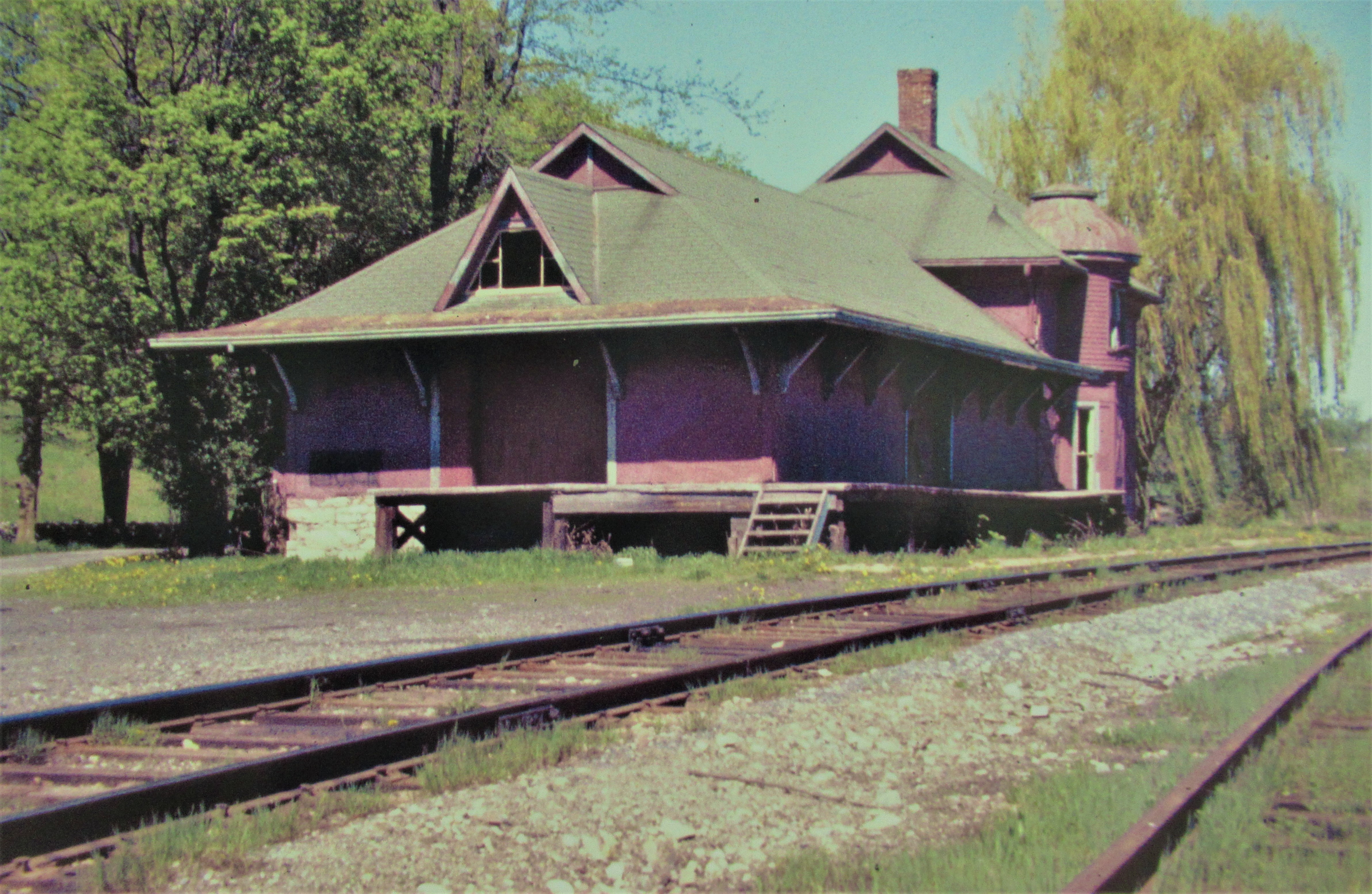
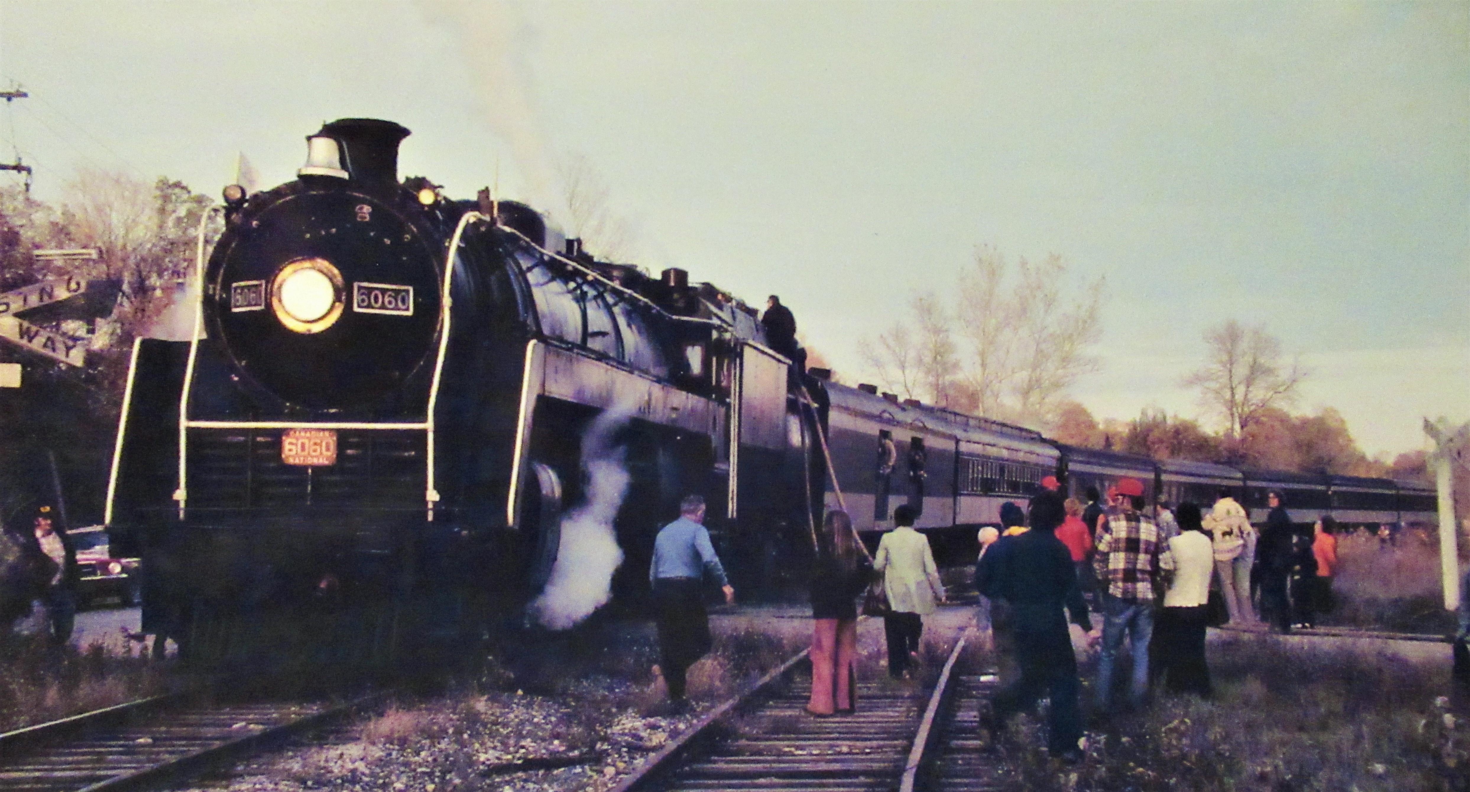
A 1971 CN track schematic showed track SA50, a 2500-foot passing track at Mi. 80 Smiths Falls Sub, visible in the foreground of the early-1970's Bill Reid photo (below). The Sydenham station's best years are definitely behind it. Most local residents now identify this as the location of The Beer Store. Just to the east was a turntable and one-stall enginehouse built at the shore of Sydenham Lake, dating from the days when Sydenham was the 'end of the line' before its extension east to Smiths Falls and Ottawa. Ottawa-Toronto fantrips behind CN 6060 would grace the line before its eventual removal. Watch for an upcoming Trackside Treasure post on the peregrinations of this perennial crowd-pleaser! This Montreal-Ottawa-Toronto fantrip, on October 17, 1977 stopped for watering by the volunteer fire department at the level crossing in the village. The special train passes the east end of the siding and Sydenham Lake at right, with daisy-pickers hanging out the open doors of the baggage car. They would be cinder-free thanks to the oil fire:
 Taking on 11,000 gallons of water from Sydenham Lake just after sunset. Operating two hours late, this detrimentally affected photography. Lots of local residents came out to see what all the noise was about! We were also there.

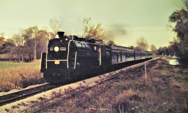
Pounding up the grade out of Sydenham. With sunset at 1830, the light was fading, but not our anticipation. Nor the the impending smoke and sound! (Three photos, Bob Hunter via Liz Reid, author collection.) Church Street crossing, near the cemetery. Perhaps it's overstating it, but the sound could wake the dead!

Though the line would see infrequent continued use into the early-1980's, including short-lived visions of a dinner-train, the end of CN's Smiths Falls Subdivision was not far off. We'll visit Harrowsmith during the CN's final days in the fifth post in this series.
Running extra...
I'm pleased that downtown Kingston's best book store, Novel Idea, now carries my latest book Smoke on the Waterfront - The Trains, Ships and Industries of Kingston Harbour. Good news - proprietor Oscar told me that customers had already been requesting the book! Not-so-good news - Oscar had no idea where to find it! Fixed.
This post is spawning an upcoming post on the peregrinations of 6060 in the 1970's, following its refurbishing for fantrip service. Based in Toronto, she sure got around! Most impressive were solo deadhead moves along the Kingston Sub with no railfan telegraph for warning - only the sound of a steam whistle!
March Forth is just past. One of the few days of the year that gives us a suggestion of something to do. Well, besides March 14! That latter day tells us what to have for dessert!
No comments:
Post a Comment