
I've received some readers' requests for further photos of the Hanley Spur. I recently explored the former Hanley Spur from nearby streets: out Ontario, Wellington, Rideau, Cataraqui and Montreal Streets and Village Drive thence John Counter Blvd, Elliott, Division, and Railway Streets back to Rideau. As you might expect, the abandoned right-of-way looks like one. Overgrown by shrubbery, a spidery gravel path in places garbage-strewn, yet retaining the unmistakable alignment and profile of a former rail line. Though I don't recall its use or removal, the former CP access to downtown Kingston was a steel girder bridge over CN's Kingston Sub east of Division Street, built in August, 1922. As shown in this Kingston street map, the bridge approach curves east to south beyond Division Street, crossing the CN double-track then continuing south between Day and Harvey Streets, before curving east near Railway Street. With the realignment of CN's Outer Station 'bend in the road', this CP bridge had to be removed.
 Top photo, from Gordon Smithson's At the Bend in the Road, Kingston (a lavishly-illustrated blended history and a must for any student of Kingston's rail history) the bridge is being removed by CP Rail crane and B&B gang in March 1974, following Railway Transport committee permission granted on February 18, 1974. The above view appears to be facing southeast.

Having crossed Elliott Avenue, the CP line (dark, curving at right of photo) headed towards Montreal and Rideau Streets. Gus Marker's brickyard occupied the current location of Kingston Police's new headquarters on Division Street. The Marker spur is visible at bottom right corner of the above aerial photo. Could that be yet another Anglin spur leading to that dark, barnlike clerestoried building middle right? The derelict towers loomed east of Division Street for years after their use ended. This photo and the ones following are photocopies made from prints held by Queen's University Archives.

These photos were taken when rails still passed the National Grocers' building. Note the CP-style switchstand marker in the foreground. Wheelstops still marked the end of the spur National Grocers' spur at Cataraqui Street.


Here's a 1970 view looking north to the Cataraqui Street crossing. A CP ice reefer is at left, with a CNR boxcar spotted at the National Grocers building (Vintage Kingston Facebook photo):
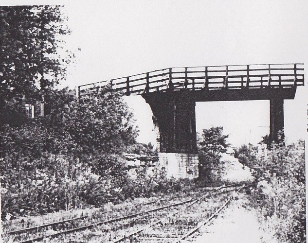
 The River Street bridge no longer exists. It's been filled in, appearing as an earthen embankment with little indication that the Hanley Spur ever passed through. These photos show the crossover under the bridge, and a turnout leads to what is likely the CE MacPherson spur.


Remnants of a tell-tale, in place to warn inattentive brakemen of the low-clearance concussion-inducing bridge timbers ahead:


In 2001, I photographed buildings along Cataraqui Street. Rosen Heating & Cooling, formerly Anglin Fuels still hosted oil tanks, and the trackage to downtown would have crossed Cataraqui Street in the foreground, heading north where the grove of trees is at left.

Backing up Cataraqui Street to the intersection with Rideau Street, this photo shows the former 'woolen mill' in the distance farthest east, with the National Grocers' building at right, and a former coal yard and office at left.

Another view at the intersection of Rideau (white stucco) and Cataraqui Streets (red brick) shows this coal yard office would make a great model. This area is desperatly trying to go 'upscale' and lacks much of the workaday character that was still apparent a decade ago.

2 comments:
The map in this post is extremely interesting. It shows exactly what I was wondering about, viz. where the CP track crossed the CN main line in order to wend its way toward downtown Kingston.
Now I am wondering: after the CP bridge was removed in 1974 how did they deliver cars to Quattrochi's?
Thanks, Drew. Glad the map was helpful. After the bridge was removed, the switching on the Hanley spur was handled by CN. CN's train could head south from the east end of the Outer Station lead, heading down the spur then backing up the former CP trackage to switch remaining customers. This connection was still available into the 80's. More here:
http://tracksidetreasure.blogspot.ca/2013/01/cns-hanley-spur-from-air.html
So, my understanding is that after the bridge was removed, CP trains into Kingston terminated at the Queens interchange, with CN's switcher dragging the cars over to the Outer Station yard, switching the spur from there...
Eric
Post a Comment